Trail Walking La Roche-des-Arnauds - Pic Chauve - Photo
 Marco05
Marco05

User GUIDE

© OpenStreetMap contributors
Length
Length
9.6 km
Max alt
Max alt
1744 m
Uphill gradient
Uphill gradient
837 m
Km-Effort
Km-Effort  
21 km
Min alt
Min alt
938 m
Downhill gradient
Downhill gradient
836 m
Boucle
Boucle
Yes
Creation date :
2022-04-01 12:02:45.051
Updated on :
2022-11-14 12:27:56.05

(0 Reviews)

Walking
Walking
4h42
Difficulty : Difficult

Scan this QR Code to open this trail in the SityTrail application

FREE GPS app for hiking

Logo SityTrail SityTrail

IGN / Geographical institutes

Download SityTrail from the App Store Download SityTrail from Google Play

Logo SityTrail SityTrail World

The world is yours!

Download SityTrail from the App Store Download SityTrail from Google Play Download SityTrail on Huawei AppGallery

About

Trail Walking of 9.6 km to be discovered at Provence-Alpes-Côte d'Azur, Hautes-Alpes, La Roche-des-Arnauds. This trail is proposed by Marco05.

Description

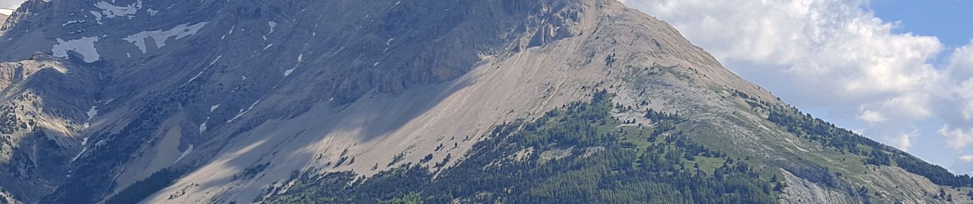
Sommet situé entre Montmaur et la Roche des Arnauds.
Le départ se situe au niveau du mur d'escalade de la Plaine.
Le final est assez pentu, et il n'y a pas de sentier sur la fin.
Bien suivre mon tracé GPS.
Au sommet, une vue imprenable sur le massif de Bure et le Dévoluy.

Elevation profile

Photos

Positioning

Country:
France
Region :
Provence-Alpes-Côte d'Azur
Department/Province :
Hautes-Alpes
Municipality :
La Roche-des-Arnauds
Location:
Unknown
Start:(UTM)
732357 ; 4938915 (31T) N.

Trails nearby

Trail Walking Montmaur - Montmaur Le Terrail - Photo
Walking
GUIDE
Marco05

Walking

Easy
(1)
Montmaur, Provence-Alpes-Côte d'Azur, Hautes-Alpes, France
5.3 km | 6.2 km-effort
1h 22min
Yes
Trail Walking Montmaur - Les Sauvas - Photo
Walking
GUIDE
Marco05

Walking

Medium
Montmaur, Provence-Alpes-Côte d'Azur, Hautes-Alpes, France
12.9 km | 21 km-effort
4h 42min
Yes
Trail Walking Montmaur - Pic de Bure par combe d'Aurouze - Photo
Walking
GUIDE
Marco05

Walking

Very difficult
Montmaur, Provence-Alpes-Côte d'Azur, Hautes-Alpes, France
14.1 km | 33 km-effort
7h 24min
Yes
Trail Walking Montmaur - Col de Conode - Photo
Walking
GUIDE
Marco05

Walking

Medium
Montmaur, Provence-Alpes-Côte d'Azur, Hautes-Alpes, France
14.2 km | 22 km-effort
4h 58min
Yes
Trail Mountain bike La Roche-des-Arnauds - La Rivière - Photo
Mountain bike
GUIDE+

Mountain bike

Difficult
La Roche-des-Arnauds, Provence-Alpes-Côte d'Azur, Hautes-Alpes, France
38 km | 54 km-effort
2h 31min
Yes
Trail Walking Montmaur - tentative de la tête du Prad Arnaud - Photo
Walking
GUIDE
nadd73

Walking

Very difficult
Montmaur, Provence-Alpes-Côte d'Azur, Hautes-Alpes, France
9.6 km | 22 km-effort
6h 32min
Yes
Trail Running Manteyer - Trail 09 - Céüze par le Pas du Loup - Photo
Running
GUIDE+

Running

Difficult
Manteyer, Provence-Alpes-Côte d'Azur, Hautes-Alpes, France
13.5 km | 28 km-effort
2h 30min
Yes
Trail Mountain bike La Roche-des-Arnauds - VTT11 - La rando du facteur - Photo
Mountain bike
GUIDE+

Mountain bike

Medium
(2)
La Roche-des-Arnauds, Provence-Alpes-Côte d'Azur, Hautes-Alpes, France
30 km | 42 km-effort
2h 36min
Yes
Trail Mountain bike Montmaur - VTT28 - Rabioux - Photo
Mountain bike
GUIDE+

Mountain bike

Difficult
Montmaur, Provence-Alpes-Côte d'Azur, Hautes-Alpes, France
24 km | 36 km-effort
2h 12min
Yes


Close
My subscriptions